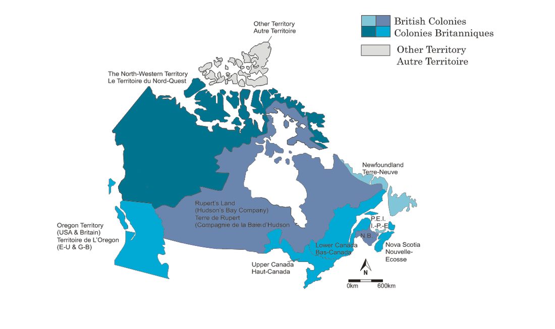
1825
Historical Information:
Following the War of 1812, immigration to North America sky-rocketed and greatly improved British North America's economy with agriculture, timber, and ship-building holding the majority of the market share. Two rebellions were led in the 1830s in retaliation to the unfair governing system as well as a prejudice against French-speaking Canadians; however, both were defeated by the British forces. In response to the rising unrest, the British government joined Upper and Lower Canada into the Province of Canada in 1841. Lastly, in 1846 Britain began limited trading with the United States and built Canada's first rail line between St. John's, Quebec, and La Prairie, Quebec.
Boundary Changes
Boundary Changes
- 1840 The Province of Canada is created by from joining Lower Canada and Upper Canada
- 1849 Border following the 49th parallel is continued to the Pacific Ocean
- 1849 The colony of Vancouver Island is established
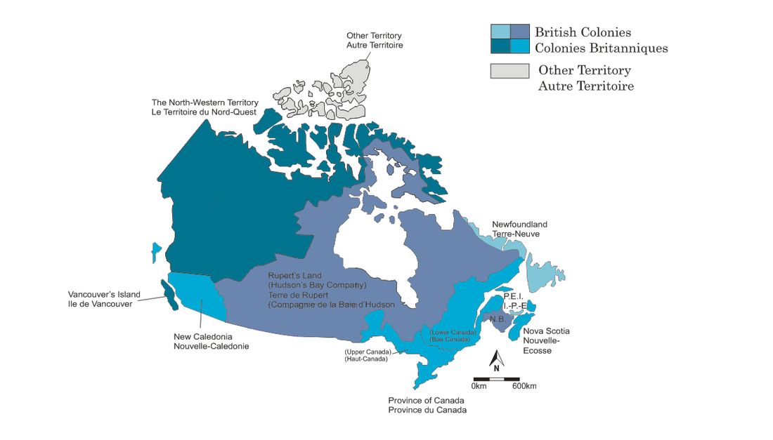
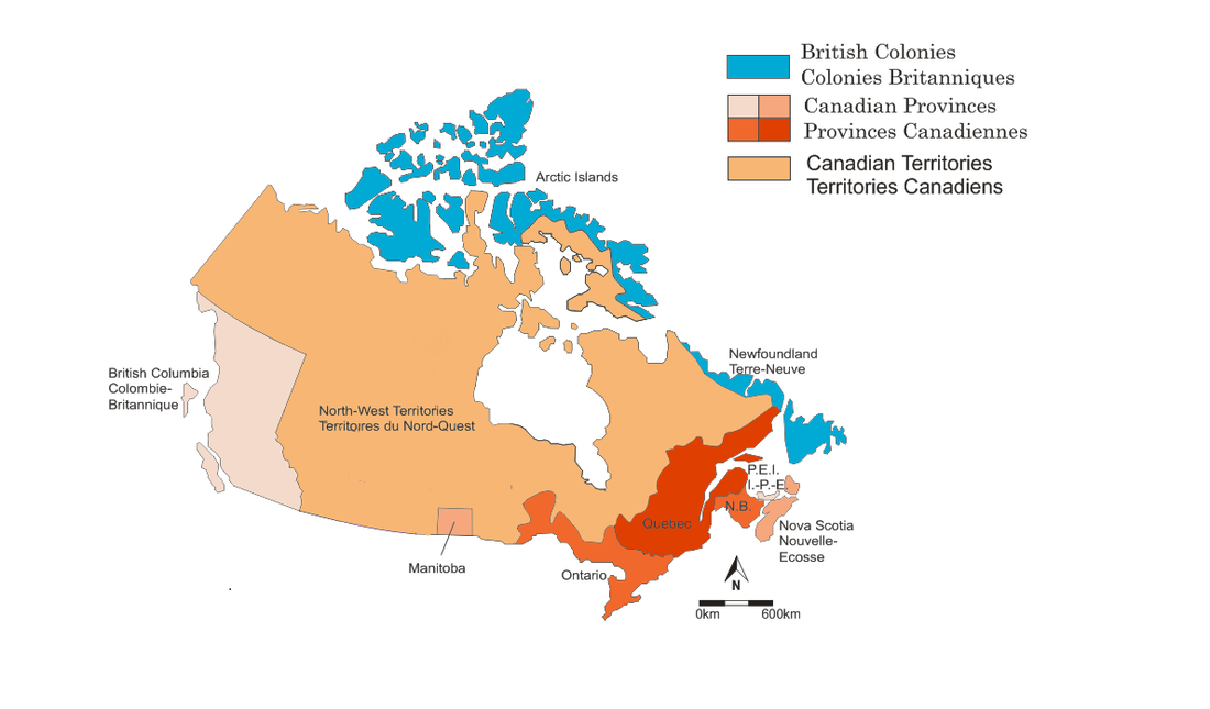
1849
Historical Information:
After many citizen's of Lower Canada lost land during the Rebellion of 1837, the Canadian government passed the Rebellion Losses Bill in 1849, which compensated these people for their losses; however, many rebels were compensated as it didn't differentiate between regular citizens and the rebels. As a result, the Parliament buildings were burnt down and were moved between Toronto and Quebec City until reaching it's final location in Ottawa in 1857. Although the map shows a united Upper and Lower Canada, the area was far from uniform. The members of Lower Canada continued to speak their own language and there was building unrest as Lower Canada had far more people than Upper Canada, yet there was no difference in legislative representation.
Boundary Changes
Boundary Changes
- 1858 British establish the mainland colony of British Columbia
- 1859 British jurisdiction established over "North-Western Territory"
- 1862 Stickene Territory created
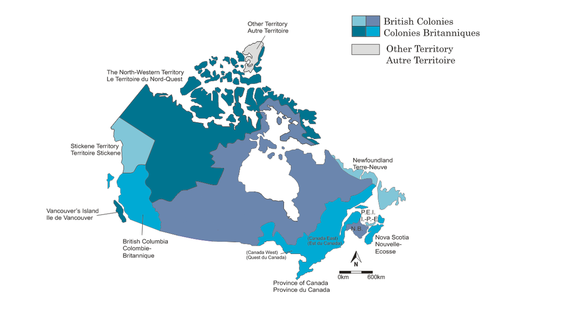
1862
Historical Information:
In the 1860s, many colonists were concerned with the American philosophy of "manifest destiny," a belief held by early Americans that they were to control all of continental North America. This concern was only heightened after the Southern Confederates, supported by the British, lost the American Revolutionary War, and many colonists feared the Northern Yankees would now turn on Canada. In response to this increased threat, the East Colonies and the Province of Canada held a conference in September of 1864 which resulted in the union of these regions to best protect them from the Americans. In 1866, this union was finalized and it was decided that the federal government would handle defense and trade and the provincial government would handle matters on a local scale. On July 1, 1867, Quebec, the Ontario, Nova Scotia, and New Brunswick were joined and formally known as the "Dominion of Canada."
Boundary Changes
Boundary Changes
- 1863 British Columbia expanded to present-day boundaries (excluding Vancouver Island)
- 1867 Confederation: The Dominion of Canada is created by uniting the provinces of Nova Scotia, Quebec, Ontario, and New Brunswick
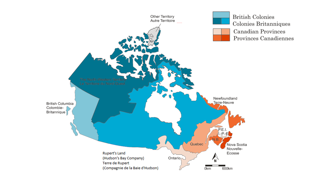
1867
Historical Information:
The Dominion of Canada aimed to expand it's territory, leading to Sir John A. MacDonald purchase of the Hudson's Bay Company's right to Rupert's Land in 1869 for 300,000 pounds. The regional Indians were not told of the boundary changes and invaded Fort Gerry and established their own government. Their list of demands of the Dominion's government got the ball rolling for the establishment of Manitoba.
As a result of the promise to build a transcontinental railroad from the East coast to the West Coast, British Columbia joined the Dominion of Canada in 1871. Prince Edward Island joined the Dominion in 1873 due to economic ruin with the pretenses that their debt would be consumed by the new government.
Boundary Changes
- 1870 Rupert's Land and North-Western Territory are transferred to Canada.
- 1870 Manitoba established as the fifth Canadian province
- 1871 British Columbia becomes the sixth province
- 1873 Prince Edward Island is added to Canada
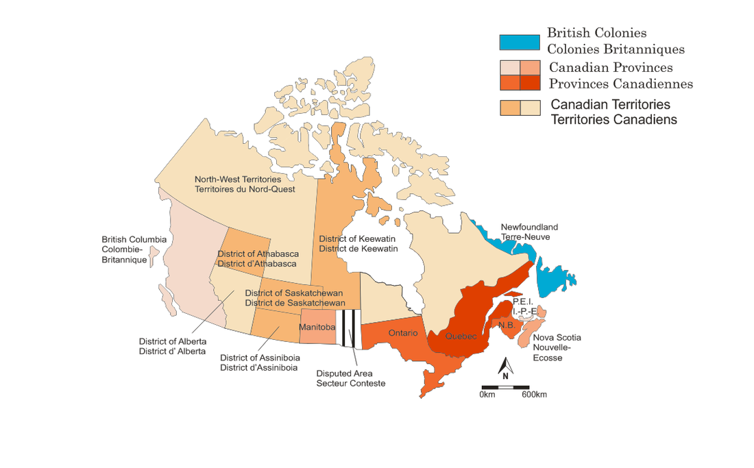
1873
Historical Information:
|
With the amalgamation of the massive North-Western Territories, a law enforcement division was needed, and this led to the formation of the North-West Mounted Police with the goal of capturing and trying criminals in the territory. The hopes of finishing the transcontinental railroad were dampened when the project was ordered to a halted after Sir John A. MacDonald was forced to leave office after a governmental scandal in 1873. However, MacDonald was voted back into office in 1878 and the project was resumed.
Boundary Changes
|
Red Ensign (1871 - 1921)
|
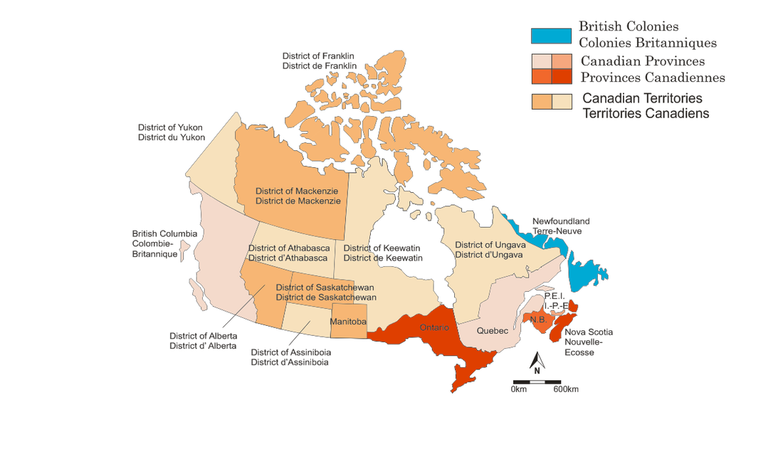
1882
Historical Information:
The transcontinental railroad, now named the Canadian Pacific Railway, was completed in 1885 in British Columbia. Sir John A. MacDonald was voted into office for a third term in 1891; but he died shortly afterwards. The government would then cycle through 5 different prime ministers from 1891 to 1896; this political unrest was blamed on the boundary disputes between Ontario and Manitoba. Lastly, women's rights were advanced in 1893 with the creation of the National Council of Women of Canada.
Boundary Changes
Boundary Changes
- 1883 Manitoba-Ontario boundary dispute is settled
- 1889 Ontario's boundary is pushed further west and north
- 1895 Districts of Athabaska and Keewatin increase in size.
- 1895 North-West Territories divided into four regions
1895
Historical Information:
As the end of the century neared, things were looking up for Canada. Wilfred Laurier was voted in as Prime Minister in 1896 and in 1901, Guglielmo Marconi received the very first transatlantic radio signal in St. John's Newfoundland. The expansion to the west was fueled by the promise of free, productive land for agriculture and this led to the addition of the provinces of Alberta and Saskatchewan in 1905. However, tensions between the French and the English Canadians were rising as the Canadian government sent nearly 1000 troops to fight in the Boer War. Much of English Canada supported the British troops, but many of the French Canadians were in support of the Afrikaners.
Boundary Changes
Boundary Changes
- 1897 Several district boundaries are adjusted
- 1898 Yukon District becomes a separate territory
- 1903 Canada loses the Alaska Boundary Dispute
- 1905 District of Keewatin renamed to "Northwest Territories," and Alberta and Saskatchewan are added to Canada
